

Discover a new side to the city’s iconic sceneries and landscapes while you explore the scenic hiking trails of Hong Kong!
Fresh air and the great outdoors are always a good idea — especially when you're craving a change of pace from city life! Hong Kong may be known for its skyscrapers and bustling streets, but there’s a whole other side waiting to be explored through its scenic hiking trails.
Many seasoned hikers tackle the city’s four major routes: the Hong Kong Trail, Lantau Trail, MacLehose Trail, and Wilson Trail. But if you're looking to mix things up, we've got you covered with a list of 12 hiking trails—ranging from iconic favourites to hidden gems tucked away in nature. Lace up your hiking shoes and get ready for a different kind of Hong Kong adventure!
12 Hiking Trails in Hong Kong For A Scenic Escape
- Ngong Ping Trail in Ngong Ping
- Finger Hill Trail in Peng Chau
- Dragon’s Back Trail in Shek O
- Sunset Peak Trail in Lantau Island
- Bride’s Pool Trail in Plover Cove Country Park
- Devil’s Peak Trail in Lei Yue Mun
- Tai Mo Shan Hiking Trail in Tai Mo Shan
- Lion Rock Hiking Trail in Sha Tin
- Lantau Peak Trail in Lantau Island
- High Junk Peak Trail in Sai Kung
- Sok Kwu Wan Trail in Lamma Island
- Cape D’ Aguilar Trail in Shek O
1. Ngong Ping Trail in Ngong Ping
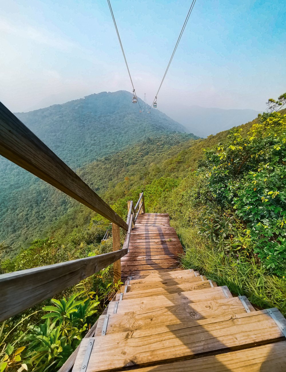
Photo Credit: Jeanne Rose Gomez on Unsplash
If you’ve gone on the Ngong Ping Cable Car, you’ve probably seen this trail below you as you traveled up to the popular attraction. The Ngong Ping Trail, known before as the Ngong Ping 360 Rescue Trail, was used for the rescue and maintenance of the attraction of the same name. Once the cable car system was constructed, the trail was paved with wooden boards for hikers to enjoy a different way to travel between Tung Chung and Ngong Ping.

Nguồn ảnh: Hong Kong Tourism Board
Hikers usually take around 4 hours to complete the 5.7km climb up to the peak, with the starting point of the hike being 1km from the ground level of cable tower no.3. At the highest point of the trail, Nei Lak Shan angled station, you’ll be treated to an unforgettable view of the blue skies and mountainous terrain of the area. The trail ends with the iconic Big Buddha in plain sight – the satisfying end to your Ngong Ping Trail experience.
Ngong Ping Trail
How to get there: From Central, take the Tung Chung Line to Tung Chung Station (Exit A). Head to Yat Tung Estate via Shan Tung Road and Yu Tung Road. From there, head past Yat Tung Estate to the start of Tung O Ancient Trail. Hike 10 minutes and the start of the Ngong Ping Trail will be on the left.
2. Finger Hill Trail in Peng Chau
If you're after a gentle, beginner-friendly hike, Finger Hill Trail on Peng Chau is a great pick. Standing at just 312 ft tall, the hill offers a short and sweet 45-minute trek along the Family Trail, with rewarding views of Lamma Island, Southside, Hong Kong Disneyland, and Discovery Bay.
Another scenic option is the Peng Yu Path—a quiet, paved trail with ocean views that leads to the remote beach at Old Fisherman’s Rock. For the best experience, start your hike in the late afternoon to catch a stunning sunset over Peng Chau.
Finger Hill Trail
How to get there: From Central, take the ferry to Peng Chau. Once you arrive at the ferry pier, walk towards Wing On Street and follow Shing Ka Road. Before the road ends, turn left onto Nam Shan Road. At the end, you’ll see signs pointing to Finger Hill.
3. Dragon’s Back Trail in Shek O
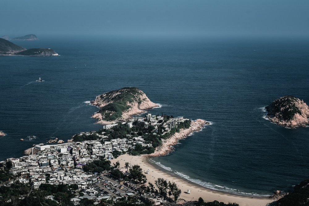
Photo Credit: drown_in_city on Unsplash
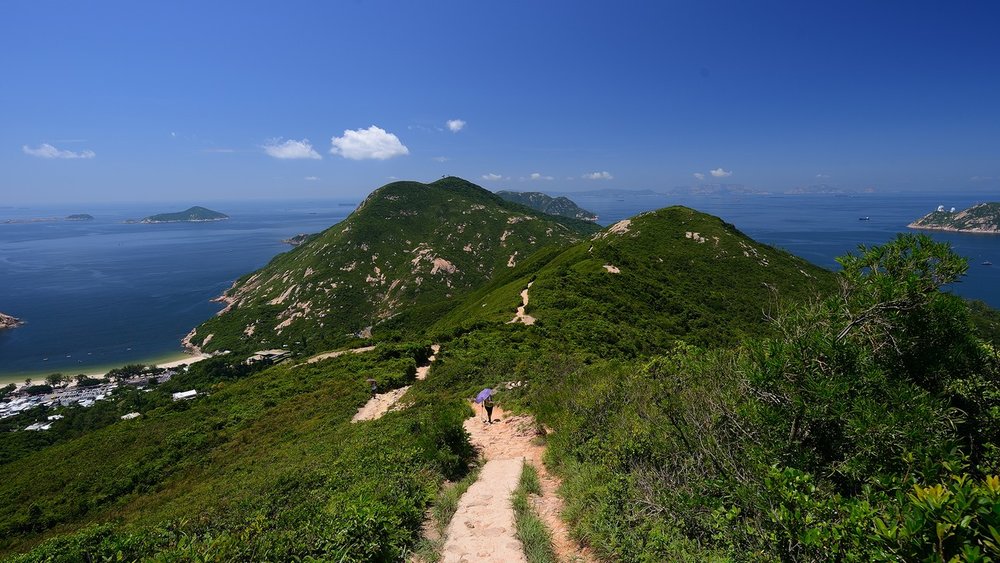
Consistently ranked as one of the best urban hikes in Hong Kong, the Dragon’s Back Trail is a must-visit for both locals and tourists. Located in Shek O, this scenic trail is known for its accessibility, moderate difficulty, and breathtaking coastal views.
Source: Hong Kong Tourism Board Website
Start your journey near Tei Wan Village on Shek O Road, and follow the path up to Shek O Peak, which stands at 284 metres tall. Once at the top, you’ll be treated to panoramic views of Shek O, Tai Long Wan, and Tung Lung Island—a picture-perfect reward for your efforts.
Dragon’s Back Trail
How to get there: From MTR Shau Kei Wan Station (Exit A), walk to the Shau Kei Wan Bus Terminus. Take Bus 9 or the minibus marked ‘Shek O’. Get off at To Tei Wan, located along Shek O Road.
Klook tip: For those who also want to go out for a dip can pack their swim gear because the hiking trail ends at Hong Kong’s surfing paradise - Big Wave Bay!
4. Sunset Peak Trail in Lantau Island

Photo Credit: Kai Chui on Unsplash
A romantic view of the city at night and a milestone climb up the third-highest peak of Hong Kong is what you’ll get with a trip to Sunset Peak in Lantau Island. The 529m ascent is quite a challenge, making it a more advanced trail to conquer compared to the others on the list. But despite this, the twilight views at the peak of the Lantau coastline and Pui O makes the journey unforgettable.
We suggest climbing to the peak in the mid-afternoon to give yourself enough time to reach the top, enjoy the sunset view, and head back before dark.
Sunset Peak Trail
How to get there: Head to MTR Tung Chung Station (Exit B). From the bus terminus next to the MTR station, take bus 11A to Pak Kung Au. Alternatively, you can also take bus 3M to Pak Kung Au from the Mui Wo bus terminal if you take a ferry to Mui Wo. Once at Pak Kung Au, turn left to the pavilion and start the Lantau Trail.
5. Bride’s Pool Trail in Plover Cove Country Park
Tucked away in the lush greenery of Plover Cove Country Park, the Bride’s Pool Trail offers a peaceful escape and a chance to see one of Hong Kong’s most iconic waterfalls. Located in the northeastern New Territories, this easy 860m loop trail is perfect for beginners and casual hikers. Want to see the waterfall up close? Make a short 700m detour to reach the Bride’s Pool Falls.
Along the way, you’ll also pass scenic spots like the Mirror Pool waterfall and the charming Bride’s Pool Stone Bridge—ideal for nature shots and photo ops! Families can start the day with a relaxing picnic at the Bride’s Pool Barbecue Site before setting off on the trail.
Bride’s Pool Trail
How to get there: From Tai Po Market MTR Station, take green minibus 2R to Bride’s Pool Road and get off at the Bride’s Pool bus terminal. On Sundays, you can also take Bus 275R, which runs directly between Tai Po Market and Bride’s Pool. The trail has two main entry points: the Bride’s Pool Nature Trail (north) and the Bride’s Pool Barbecue Site (south).
6. Devil’s Peak Trail in Lei Yue Mun

Photo Credit: Sergio Capuzzimati on Unsplash
Don’t let the name intimidate you—Devil’s Peak Trail is actually a short and fairly easy hike that's perfect for a quick nature escape without straying far from the city. The trail offers a great mix of history and panoramic views, making it a favourite among casual hikers and history buffs alike.
Historically, this hill was once occupied by pirates during the Ming Dynasty, and later served as a British military post in the early 20th century. Today, it’s a scenic hiking spot where you can climb up to 222 metres above sea level and enjoy sweeping views. From the summit, soak in a dual perspective—with Victoria Harbour and the city skyline on one side, and Junk Bay and LOHAS Park on the other.
Devil’s Peak Trail
How to get there: From Domain Mall, exit to Ko Chiu Road and head towards Lei Yue Mun Estate. Walk up to the Tseung Kwan O Chinese Permanent Cemetery until you reach the start of the Wilson Trail, then follow the signs to Devil’s Peak.
7. Tai Mo Shan Hiking Trail in Tai Mo Shan

Photo Credit: Peter Lam CH on Unsplash
Ever wondered what it’s like to climb a volcano? Wonder no more and check out the Tai Mo Shan Hiking Trail! The now-extinct volcano is Hong Kong’s highest peak and can be climbed on a whopping 957m journey! Start off the uphill climb at Tai Mo Shan Road, located nearby Rotary Park, one of the popular cherry blossom viewing spots from February to March.
When you reach the peak, feel as though you’re on a bed of clouds as you roam around at the top to enjoy different angles of Kowloon reservoir, Tsuen Wan, and maybe even mainland China's scenic views!
Tai Mo Shan Trail
How to get there: Head to MTR Tsuen Wan Station (Exit A) and take bus 51 to Country Park Station. You can also choose to get off at Kwai Hing or Tai Wo Hau Station on the red line and take a cab to Lead Mine Pass.
8. Lion Rock Hiking Trail in Sha Tin
Klook Fun Fact: The Lion Rock formation is believed to embody the resilient spirit of the Hong Kong people!
What better way to connect with that spirit than by hiking to this iconic landmark? The Lion Rock Hiking Trail is one of the most legendary hikes in Hong Kong, best suited for hikers seeking a moderate challenge. Expect steep ascents and a mix of terrain, including paved paths, makeshift staircases, and natural rocky trails.
At 495 metres high, the summit offers breathtaking 360° views over Kowloon, Hong Kong Island, and the New Territories—a rewarding finish for those who make the climb. With minimal shade along the way, don’t forget to pack sunscreen, water, and a good pair of hiking shoes!
Lion Rock Trail
How to get there: Start from either Wong Tai Sin MTR Station or Sha Tin Pass Road, depending on your chosen route. From Wong Tai Sin, take a short taxi ride or minibus to Fat Jong Temple at Sha Tin Pass, where the trail entrance begins.
9. Lantau Peak Trail in Lantau Island

Another hiking trail on Lantau Island is the Lantau Peak Trail. With the peak located 934m high from the base, hikers can enjoy the rising or setting sun over rural villages surrounded by scenic mountainscapes. One thing to keep in mind about the trail is that the descent can get quite steep, so don’t hesitate to take it slow.
For the best views, we recommend scheduling your hikes 2 hours before either sunrise or sunset to give you enough time to reach the peak. For those looking to experience the sunrise at Lantau Peak, we suggest a hike during the months of December and February for fewer clouds to obstruct your view of daybreak.
Lantau Peak Trail
How to get there: Head to MTR Tung Chung Station (Exit B). From the bus terminal next to the MTR station, go on a 50-minute ride on bus 23 and get off at Pak Kung Au.
10. High Junk Peak Trail in Sai Kung
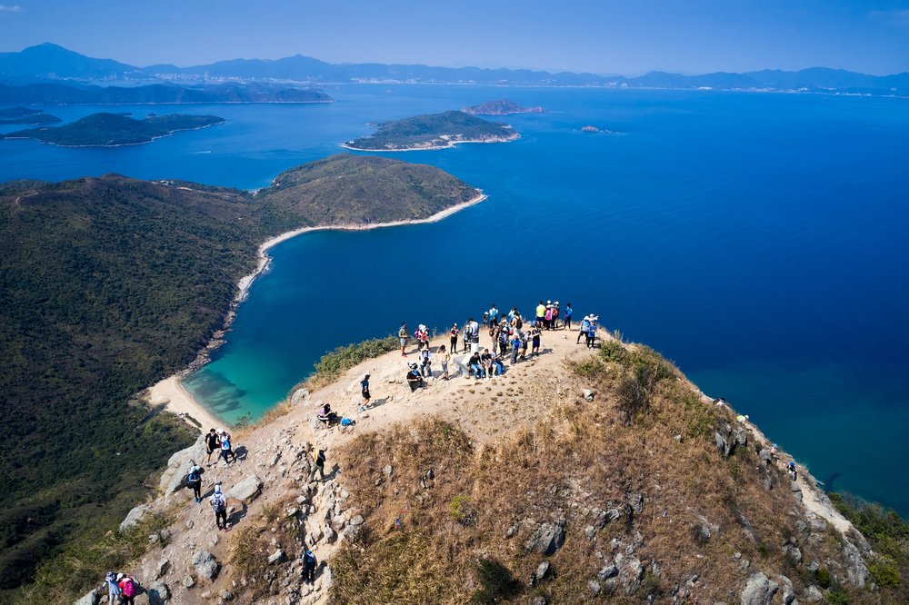
Photo Credit: Tim Cheung on Unsplash
Head to one of the three sharpest peaks in the area with a trek up High Junk Peak in Sai Kung. From Ng Fai Tin, hikers start the climb up the High Junk Peak Country Trail, which include the sceneries of Tseung Kwan O and Sheung Sze Wan during the ascent. The last leg of the hike can get a bit tricky with the section near the peak getting steeper and rockier. For an alternative - the country trail is available and far less daunting.
The 8.5km challenging trail usually takes hikers 3.5 hours to accomplish, but the stunning panoramic bird’s eye view of Clear Water Bay is worth the trip!
High Junk Peak Trail
How to get there: From Diamond Hill Station, take Exit C2 and ride the bus to Ng Fai Ti. From Hang Hau Station, take Exit B1 and to the bus terminal. Ride green minibus 103 and get off at Ng Fai Ti.
Klook tip: Adventurers also into mountain biking can try out the mountain bike trail open during the weekdays. Strap on your protective gear during the steep ride!
11. Sok Kwu Wan Trail in Lamma Island
Sok Kwu Wan Trail in Lamma Island is one to try if you’re looking to experience a different kind of hiking trail! Sok Kwu Wan, with its circular-shaped trail, is often called the Lamma Island Loop. Its 10km path extends from the southern part of the island, starting from Sok Kwu Wan to Mo Tat Wan, Yung Shue Ha, Tung O, and back again to Sok Kwu Wan.
The landscapes and villages you’ll pass by during your hike make the adventure even more exciting! Make a stop at the small village of Mo Tat Wan for a much-needed break then continue on to Yung Shue Ha for some beach fun. One thing is for sure - no matter where you stop, you’ll be guaranteed stunning views of the sea, Lamma Island, and Hong Kong’s south side.
Sok Kwu Wan Trail
How to get there: Take a ferry from Central Pier 4 to Sok Kwu Wan. You can also choose to take a kai-to (small ferry) from Aberdeen to Sok Kwu Wan and get off at Mo Tat Wan to start your hike.
12. Cape D’Aguilar Trail in Shek O
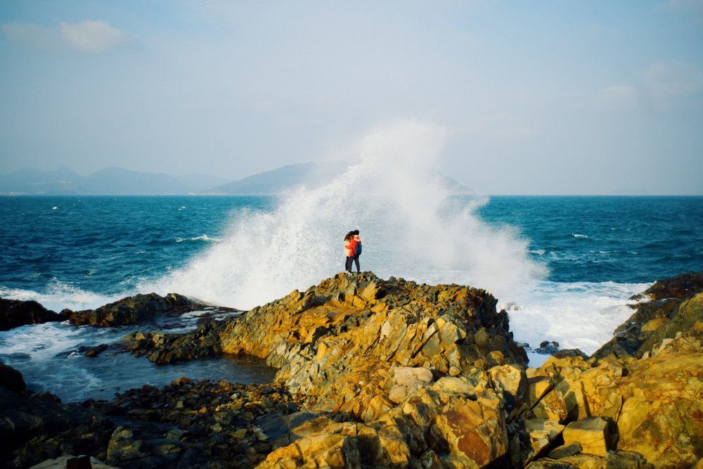
Photo Credit: Joseph Chan on Unsplash
Another beginner-friendly hike on the list and one shutterbugs should keep on their radar is the Cape D’Aguilar Trail! The popular hiking trail is known for its Instagram-worthy sceneries and popular natural attractions like the Thunder Cave. Hikers begin the journey at Cape D'Aguilar Marine Reserve and head off on an 8km hike that usually takes 3.5 hours to finish. A good majority of the hike is traveled on paved roads and flat land which makes it an easy route for all hiking levels.
One of the most iconic photo spots during the hike is at Crab Cave, where you can capture the crashing waves as your backdrop, so don’t forget your camera!
Cape D’ Aguilar Trail
How to get there: From Shau Kei Wan MTR Station (Exit A3), head to the bus terminal and hop on bus 9 to Cape D’ Aguilar and Shek O.
Travel Essentials for Hong Kong

Photo credit: @takuya_hk
Before hitting the hiking trails or city streets, make sure you’ve got these essentials ready:
- Octopus Card – The easiest way to get around on Hong Kong’s MTR, buses, and ferries. You can top it up as you go!
- Klook eSIM – Stay connected instantly with a Klook eSIM—no physical card needed! Just scan, install, and you're online the moment you land.
- Hong Kong Airport Transfer – Make your arrival stress-free with a pre-booked airport transfer to your hotel. Book it on Klook for a smooth start to your trip!
- Comfortable Walking Shoes – Whether it’s uphill climbs or exploring markets, your feet will thank you.
- Sunscreen & Reusable Water Bottle – Hong Kong gets hot and humid, especially on hikes. Stay hydrated and protected.
- Cash & Credit Card – While most places accept cards, some local spots and dai pai dongs (street food stalls) are cash-only.
🎒 Bonus tip: If you’re hiking, pack light but bring bug spray, a light rain jacket, and Google Maps offline—just in case.
More Hong Kong Inspiration


What is Klook?
Klook is a leading pan-regional experiences platform in Asia Pacific, purpose built to digitalize experiences and make them accessible to every traveler.
Our mission is to build the digital infrastructure for the global experience economy — empowering merchants to share their passions and travelers to discover the heartbeat of each destination. We operate a mobile-first, curated platform featuring diverse experiences across global destinations.